News & Topics
- 17th October 2025
- High School Students from Yamaguchi Prefectural Technical High School Visited Our Center
- 20th-21th September 2025
- “Summer School 2025” was held on Hashima Island in Iwakuni
- 10th October 2025
- The Open Campus was held at the Tokiwa Campus of Yamaguchi Universityd
- 26th March 2025
- Collaborated with Hosei University
- 18th March 2025
- Visiting to Srinakharinwirot University, Thailand
- 24th January 2025
- “8th SYMPOSIUM Human Resource Development and Space Data Utilization for Disaster” has been held
- January 2025
- Collaborated with ArcEdge Space Co. Ltd.
- 7th December 2024
- “8th Seminar of Space Education and Growing Industry” has been held
“ICCT-Pacific 2026” was held at Yamaguchi University's Yoshida Campus
The 2026 IEEE 2nd International Conference on Consumer Technology – Pacific (ICCT-Pacific 2026) was held at the Yoshida Campus of Yamaguchi University from March 28 to 30, 2026.
Associate Professor Toshikazu Samura and Assistant Professor Thanawit Gerdprasert organized a special session, where Assistant Professor Trinh Xuan Truong presented his research.
MORE DETAILS
“The 9th Space Education × Growth Industry Promotion Seminar” was held
On December 13, 2025, the 9th Space Education × Growth Industry Promotion Seminar was held, co hosted by Yamaguchi University and the Ube City Board of Education.
This year’s seminar focused on the emerging field of spaceports, featuring three invited experts.
MORE DETAILS
“Open Data Academy 2025” was held on Tokiwa Campus in Yamaguchi University

On 16th November, 2025, “Open Data Academy 2025” was held on Tokiwa campus in Yamaguchi University.
Ten junior high school students from Yamaguchi Prefecture participated in the program, where they received lectures and hands on training on the use of open data and satellite data.
Thank you to all the visitors.
MORE DETAILS
Development of Near-Real-Time Image Processing Technology on Small SAR Satellite
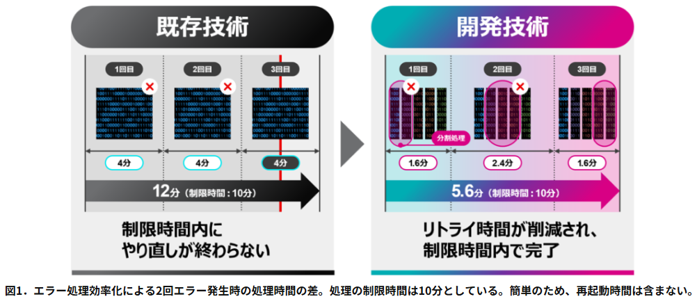
Yamaguchi University and Fujitsu Limited have developed the Near-Real-Time Image Processing Technology for small SAR satellites.
This technology can perform near-real-time image processing on a satellite under the effects of cosmic radiation and limited power conditions, and it supports the safe navigation of ships.
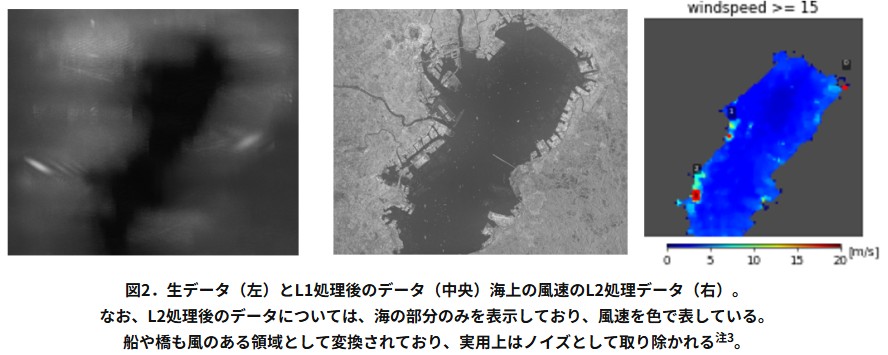
We succeeded in calculating the ocean wind speed using a prototype model that simulates a satellite.
MORE DETAILS
Message from the Director
Improving relations between humans and our earth using satellite remote sensing technology
Our center aims to further develop satellite remote sensing utilization techniques, as well as train scientists and engineers in the field, spreading satellite remote sensing utilization across the entire globe. The benefits that remote sensing technology offers are immeasurable, ranging from helping protect peoples' lives in disaster areas to stable harvesting of foods.
In addition, remote sensing can contribute to environmental conservation across the globe by providing accurate information on environmental issues such as illegal deforestation and marine pollution. There are many potential global issues looming in our future, and we believe that with sensor improvement and analysis development, satellite remote sensing will play a major role in the solution of these significant issues. We see great potential for the future of remote sensing techniques.
We at Yamaguchi University are committed to publishing the newest, cutting edge research results satellite remote sensing data and fostering world-class specialists who will become global leaders in the field.
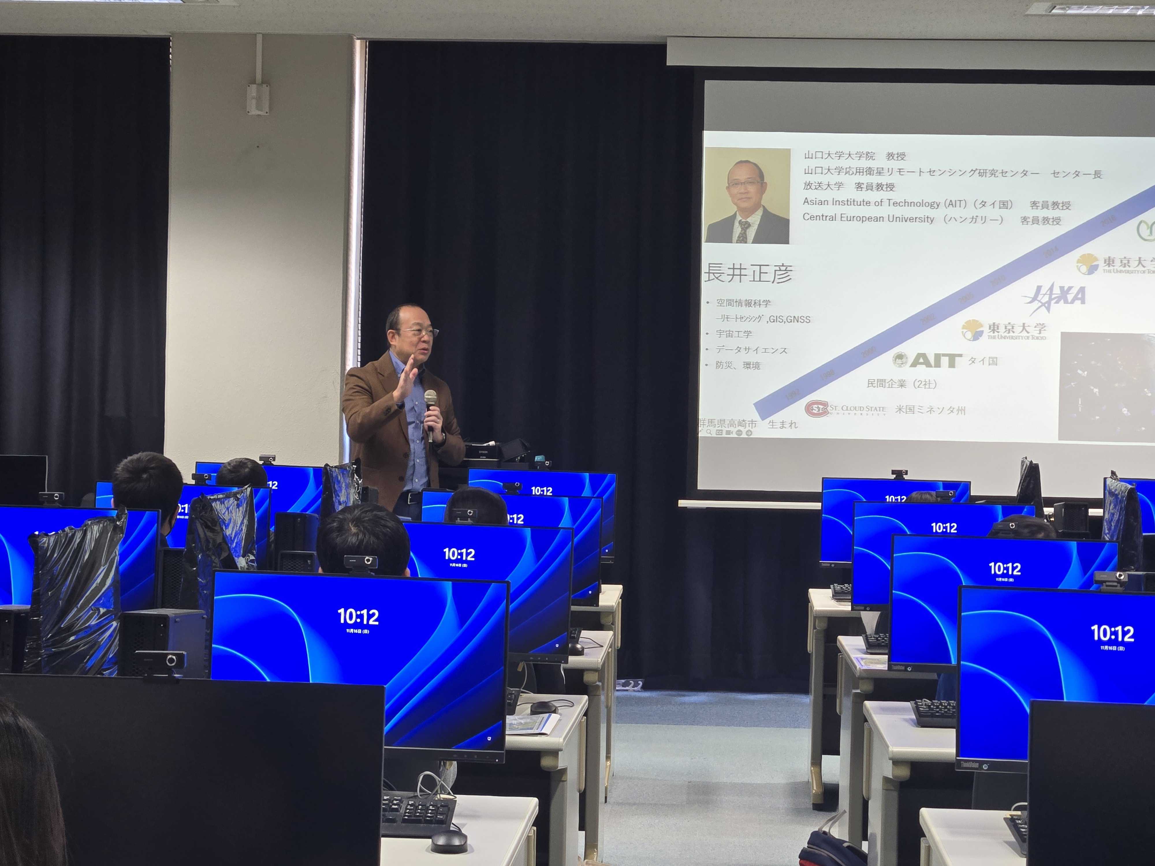
Director, Masahiko NAGAI
Our 4 Missions
Mission 1
To promote world-class research insatellite remote sensing
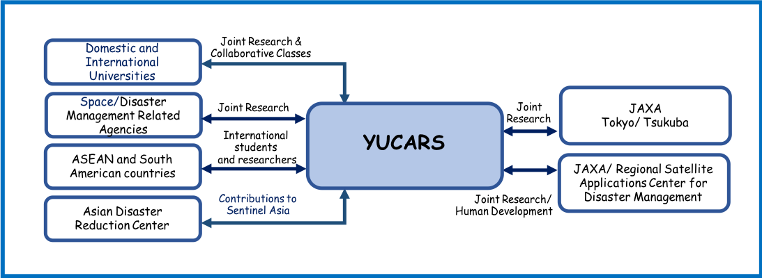
Our center hosts researchers from various academic backgrounds including engineering, agriculture, humanities, economics, and medicine and health sciences and uses this fact to promote interdisciplinary research. As we continue our work, we aim to work even harder to strengthen our partnerships with overseas researchers.
Mission 2
To cultivate human resources capable of promotinga wide range of research in satellite remote sensing
and space technology
Satellite remote sensing data are only simple numerical values, but there is a large quantity of data. To handle the enormous volume of data, it is necessary to foster human resources with advanced and specialized knowledge, such as data-scientists who can solve problems through high volume data analysis techniques and visualization and analysis using IoT. Our center accepts domestic and overseas students and trainees especially from Asian region to fulfill this goal.
We have conducted research and educational collaborations with Udayana University, Indonesia for 10 years, and deliver lectures to both classes (Japan and Indonesia) concurrently by connecting the classes online.
We have also introduced a double degree program that turns out quality master and doctoral degree recipients. We plan to expand these projects to other universities in the Asian and South American regions.
Mission 3
To contribute to disaster information analysis and improve public safety and securityWhen a large-scale disaster occurs, it is extremely important to first understand what happened and where. After the East Japan great earthquake disaster, the delays in understanding the overall situation slowed initial rescue activities and reduced their effectiveness. This meant that many people who survived the quake's destructive shaking and following tsunami still passed away without access to rescue. In the near future, Japan faces potential large-scale disasters, such as a Nankai Trough major earthquake, a Tokyo inland earthquake, super typhoons, and torrential heavy rain.
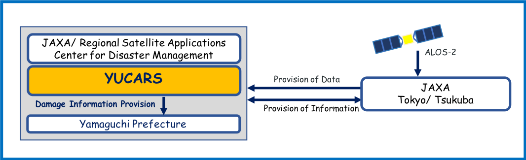
To prepare for disasters, we research use of satellite remote sensing to quickly analyze damage post-disaster (what kind of damage and where), and provide that information to administrative agencies and disaster related agencies in collaboration with Japan Aerospace Exploration Agency (JAXA) and other domestic and foreign universities.
Mission 4
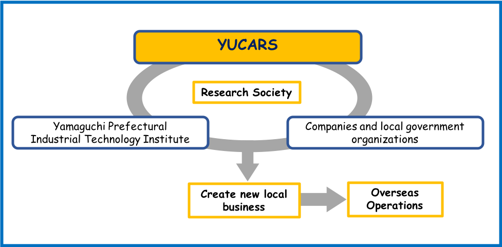
To promote local industry and create new industry/business for space utilization technologyWe find real applications for our research results on satellite remote sensing and space technology utilization through industry-academia-government collaboration. New industries and services linking us with users worldwide are an essential key to a more successful spread of these applications.
Thus, our center has established a study group for analysis and utilization of satellite remote sensing data together with Yamaguchi Prefectural Industrial Technology Institute and local companies. It contributes the creation of local new industries/business and development of overseas operations.